Safety notes: open water crossing
After making my way through the American Packraft Association’s new video series Be WaterWise, I was inspired to put together a few thoughts on Packrafting Safety. You can find the videos on the APA YouTube Page. They are worth a watch, they do a great job of covering safety basics for paddling, especially rivers. Rather than review the topics covered so well in the videos, I figured I would add to the safety conversation, by covering an additional topic: open water crossing.
With windy Fall days here in Maine, I have been thinking about this topic a fair amount recently. On a few recent bikerafting clinics I relied on a rubric, I learned a long time ago as a canoe guide. It was a big help in making sure we made the safest a well as most efficient crossing possible. Thinking about open water paddling in this way is helpful no matter what boat you happen to be in on that trip. By answering a few questions about the three things below you are setting yourself up to to fully assess the risk you are about to face.
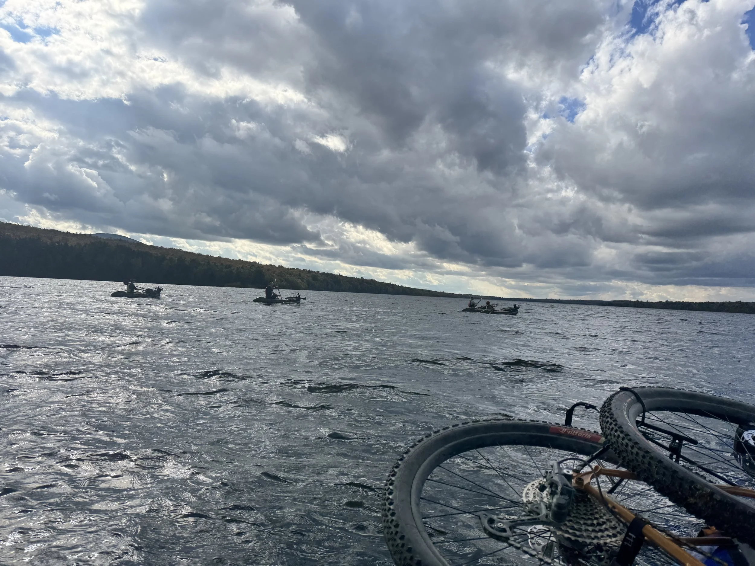
Bikerafters crossing Second Roach Pond
Weather
Current conditions?
Expected changes?
Fetch and all the Lees
Where is the wind coming from?
Where is the wind going?
Route and Group
Does everyone know where you want to go?
How might wind and waves change your route?
Will everyone be able to stay together?
Weather
Reading the weather is a difficult skill that takes years of practice in that particular area. I feel lucky when I get to aeventuate with people who know a place well. With just a change in wind direction, or cloud type they already have an idea of how the weather is likely to change. Even when we aren’t traveling with the attuned, we can still pick up on a few cues and use them to make informed choices.
When I am paddling a route that I know will have some larger open water crossings I try to ask myself a few questions, starting even before I get there. Running through my mind as I approach the point I want to start the crossing:
What are the current weather conditions?
Is it windy or calm?
Is it cloudy or clear?
Have the conditions been steady all day or have they been changing?
Do the clouds look different than earlier in the day?
Has the wind changed directions recently?
Was it a small shift of a few degrees?
Or did it flip 180 degrees?
Has the wind been getting stronger recently?
As I answer go through these questions, my main concern is rate of change. If I am confident that the conditions I am seeing now will last for the time I need to make the crossing, then I can make an informed decision. Go? On the other hand, if the weather seems likely it is changing quickly and will likely be different before I finish the crossing, then I can not make an informed decision. Stop!
Fetch and all the Lees
These are two ideas that come from sailing, so they will feel overly confusing, but we can keep them simple. Fetch is the distance wind travels over water. The Lee (opposite of windward) is where the wind is going. When we choose where we make an open water crossings we are making a choice about the Fetch and Lee at that spot. Here is a map from a recent bikerafting trip I did.
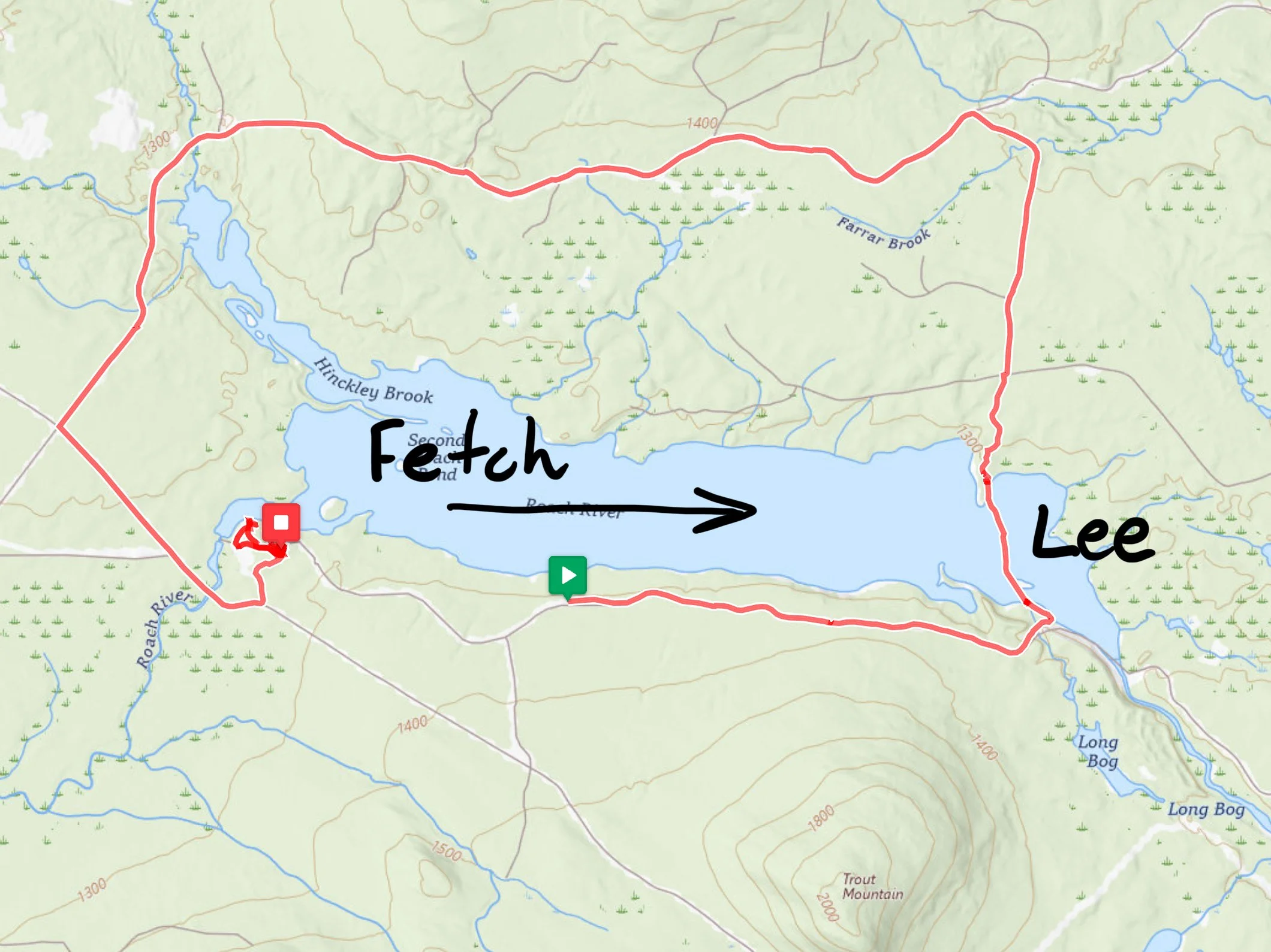
Second Roach Bikerafting Loop (I turned on tracking a little late…)
We biked along the South shore on Second Roach Pond and set ourselves up for a crossing on East side of the pond. That day the wind was blowing from the West to the East. The wind was consistently around 12-15mph, which we could see from the occasional whitecap on the waves.
Fetch- Since our crossing was on the East end of the pond and the wind was traveling the length of the pond (about 2 miles) before it reached us there was considerable fetch, this meant we were likely to see more waves than were on the West side. This isn’t great, but based on the waves we saw when we got ther, it was still a safe crossing.
Lee- Since we were very close to the East end of the pond there was very little water left “to our lee.” That’s just sailor talk meaning the side the wind is going to. I prefer a crossing where is don’t have much water to my lee. This means that if something goes wrong and I have to stop paddling, I will be pushed towards shore.
For this crossing the fetch was a slight concern, especially if I had been worried it would get windier. However the weather was stable so even with the fetch I thought it was a safe crossing. Go?
In addition the lee side was minimal so that was also a good sign. Go?
Route
Sometimes the hardest part of a crossing is communicating, and that only gets harder when you are out on the water, and it is windy and wavy.
Before you start paddling you need to make sure that everyone knows:
where the final destination is
where it will be windiest
what to do if the group starts to get separated
Let’s return to the route from the recent bikerafting trip, but this time zoomed in on the crossing.
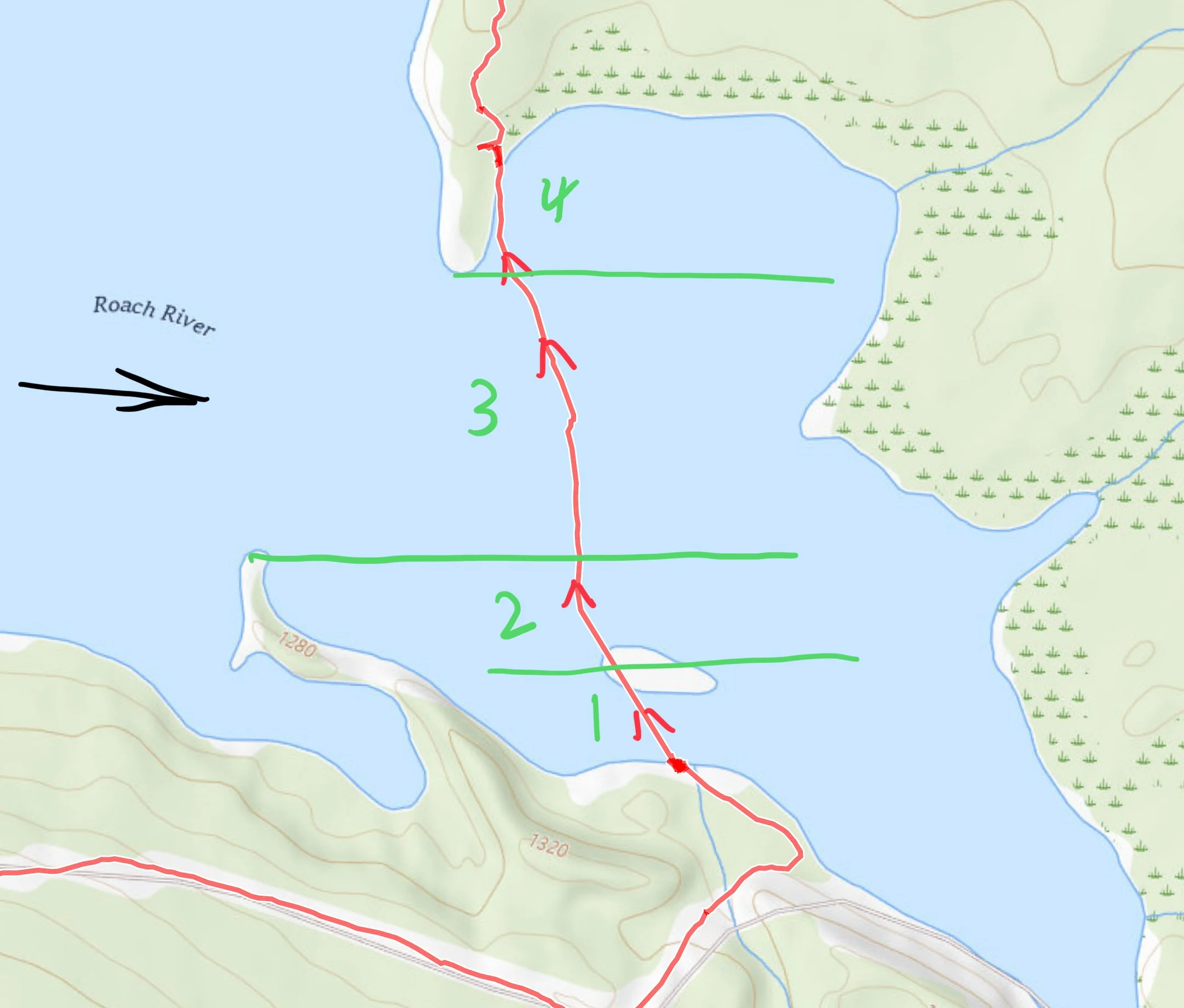
A close up on the crossing, with 4 different zones marked.
We were headed from the South shore towards the North shore. One thing that made our decision tricky was that we were in a calmer protected area, with our view of the crossing partially blocked by the Island. Looking at the map and thinking about the wind direction I knew we go through 4 distinct zones: 1) a calm area before the island, 2) an area where the wind and waves were building as we got closer to the point, 3) an open area where the wind and waves were unblocked for the length of the pond, 4) and finally a calm area behind the point.
This was reasssuring because I was confident that in Zone 2 we could safely decide if it was safe to cross Zone 3, or if we needed to turn back. I also felt the group was paying attention and capable of paddling in a steady breeze with small chop, but probably not a large chop.
Final Decision
When we got to Zone 2. I had been going through the questions listed above and made the following judgment calls:
Weather:
Steady breeze, with small chop- Go?
Has been steady throughout the day- Go?
Fetch and Lees
We have a short fetch in zones 1,2, and 4. We have a long fetch in zone 3
This means the Go/Stop decision is based on what we see in zone 3
We found small chop in zone 3- Go?
We have a short lee the whole route- Go?
Route and Group
We knew where we needed to go- Go?
We could handle the level of wind and chop- Go?
We could stay together easily in the current conditions- Go?
Based on the rubric we had no Stops and all Goes. So I felt that it was safe to make the decision to do the crossing on that day. If what I was seeing led me to a Stop on any of the above we would not have done the crossing It doesn’t matter how many of the other signs looked good.
Hope this helps, reach out with any questions.